Measuring a plot, there are many reasons to want one. But how do you actually do it? Do you need to hire a surveyor to do it or can you do it yourself? And what should you do?
You can survey a plot yourself. It is not difficult with Apglos Survey Wizard. There are other possibilities, but the choice to measure your plot depends very much on the accuracy you require of the measurement. Measuring a plot can be done with centimeter accuracy, but it can also have a deviation of several meters. Based on the measurement of your plot you can determine the area and lengths. The correctness of the results depend on the accuracy with which the plot was measured.
To make everything clear on this topic, we will answer the following questions in this article:
- What are the pros and cons of measuring a plot online?
- Measuring a plot via Google Maps, how do you do it?
- Can the Land Registry measure a plot of land?
- What is the best plot measuring app?
- What is the cost to measure a plot?
Measuring a plot: the solution
You may not have the opportunity to read this entire article. Therefore, there is another opportunity to learn more about How accurate is GPS?.
You can try a GPS measurement system through this website. You can then see for yourself how accurate GPS is. Look directly at this page.

You can request a demonstration of one of our GPS surveying systems on the same page. At this demonstration you can then also ask specific questions about how accurate GPS is and of course other topics related to GPS surveying.
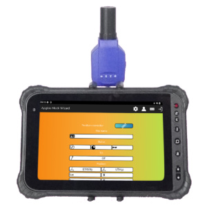
If you don't have time for a demonstration or want to try the software of our GPS measurement systems quickly in between, that is possible. Apglos Survey Wizard is the easiest software to perform GPS measurements with. You can download it for free from the Google Play Store.
The surveying app Apglos Survey Wizard has full functionality with your Android device's GPS. So you can fully test this app and it is free.
Of course, the accuracy of our GPS receivers is better than that of standard Android devices. But you can read all about that on this page. Therefore, if you want to do a test with an accurate GPS system, check out this page.
What are the pros and cons of measuring a plot online?
You can measure a plot online. In itself, it is not that difficult. The best known way is with Google Maps. How to measure a plot using Google Maps is explained later in this article.
But first, the benefits. I've actually already mentioned the first advantage. It is easy. Especially if the plot measuring is done with Google Maps. Everyone knows Google Maps. By many it is used to navigate in the car. But otherwise, you might use it to look up a place name so you know exactly where it is.
So it works much faster and easier than the old maps. With that we immediately have the second advantage. And so that is that it is fast. To measure a plot online with Google Maps, you don't have to go outside. You can just click on the points on the map. Then you will know approximately the length of the boundary and approximately the area of the plot.
And that's also the big disadvantage of measuring a plot online. Google Maps can only zoom in to a certain level. This means that placing a point on the map is much less accurate than if you measure outside.
For an indication, measuring a plot online is good. But if you actually want to know exact values of length and/or area then it is wise to have the Land Registry, or a surveyor measure the plot or do it yourself with the best plot measuring app, among others.
More about both possibilities later in this article.
Measuring a plot via Google Maps, how do you do it?
But now first about how to measure a plot using Google Maps. First of all, you need to go to the website containing Google Maps via your Internet browser.
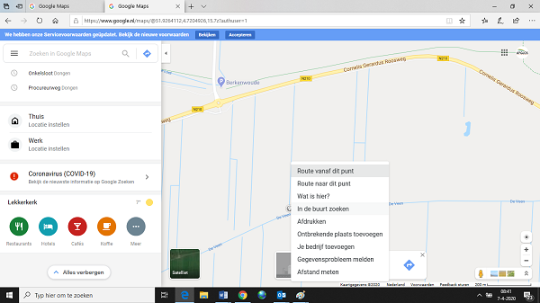
When you have Google Maps in front of you, right-click on the map at the starting point of the plot. A drop-down menu will appear. At the very bottom is “Measure Distance.” You click on this option.
Then click on the map on the vertices of the plot you want to measure. The last vertex you should click on is the vertex where you started.
At the bottom of your image, you will then see the area of the plot and its length.
As you can see, this is a simple way to measure your plot. It's just not that accurate.
Can the Land Registry measure a plot of land?
If you want to have the plot accurately measured then there are two options. The first is to have the Land Registry measure the plot. Another possibility is to measure the plot yourself with the best plot measuring app. More about the latter possibility is described later in this article.
One of the tasks of The Land Registry is to designate parcel boundaries. The Land Registry is the body that keeps and manages the exact location of plot boundaries. So it makes sense that when a plot needs to be measured, you think of the Land Registry.
And the Land Registry also measures plots of land. However, Land Registry surveyors are often used for to plot the exact plot boundary.
This often happens on programs like The Driving Judge. And so it often happens when there are problems between two neighbors regarding plot boundaries.
When there is such a conflict, it is also wise to hire a surveyor from the Land Registry. This is because the Land Registry is an independent party that values indicating the correct location of the plot boundary.
If you only want to measure the plot then you can also use a company surveyor. This applies unless a new boundary needs to be established. Then it is again wise to get a land surveyor from the Land Registry involved.
In short, the Land Registry can certainly measure a plot. But so can other surveyors. And as you can see further on, you can do it yourself. The choice you make should depend on the situation and perhaps the price, but more on that later in this article as well.
What is the best plot measuring app?
The best parcel surveying app is Apglos Survey Wizard. This land surveying app can be downloaded from the Google Play Store.
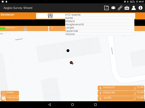
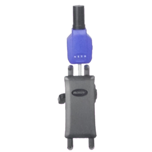
This app allows you to use GPS to measure your plot. In your phone or tablet there is a GPS module. This GPS module determines the position where you are. This can also be used for measuring the plot. Only you should know that the accuracy of the GPS of your phone or tablet is not that high. This is around 5 m.
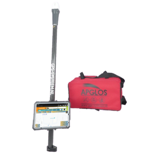
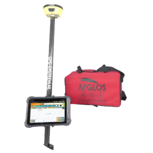
If you want to measure your plot more accurately then you can connect the best plot measuring app Apglos Survey Wizard to an external GPS receiver. When you do that you will get results with centimeter accuracy.
You will get the same results as if you hire a surveyor from The Land Registry or any other company. This is possible because Apglos Survey Wizard is the best plot surveying app.
And it is because Apglos Survey Wizard is tremendously accessible and can be used by anyone. The reason for this is that:
- Apglos Survey Wizard is also in the Dutch language
- There are easy tours for the most commonly used functions
- The base is similar to Google Maps
- Large and clear buttons
That's why Apglos Survey Wizard is the best plot surveying app.
What is the cost to measure a plot?
Then, finally, there is the cost of measuring a plot. The cost depends on the method.
If you measure the plot online on Google Maps, there is no further charge.
However when you want to measure your plot accurately that there are costs. Only the cost differences are large. The rates of a surveyor from the Land Registry are on this page. You should quickly think of a minimum rate of € 485, -. And this amount can increase.
Surveyors from other companies may have a slightly lower rate. In 2020, a surveyor with GPS costs about €61.50 excluding VAT per hour. But that's without call-out charges and in addition they often charge per half day. Based on this, a half day costs about € 400, - excl. VAT.
And often surveying a plot does not take 4 hours. This means that the cost of surveying for a plot from a surveyor is quite high.
A more economical solution is to do it yourself hire of a GPS system with the best plot surveying app Apglos Survey Wizard. This can be done on this website for as little as € 50, - excl. VAT per day. And if you want to measure more than 10 plots, it is even more economical to buy a GPS measuring system.
You then have everything under your own control, and with the surveying app Apglos Survey Wizard, you can do it yourself.
Final conclusion on measuring a plot
This was a whole article about surveying a plot. There is a lot to report on this topic of GPS surveying. So we hope that you have picked up at least a few things from it and can take advantage of them.
However, everything written in this article is theory. If you want to put this theory into practice you can.
Indeed, you can use this website to purchase a GPS measurement system try or buy. When you do then you can immediately put into practice what you learned by reading this article about measuring a plot. And you can see if working with our GPS measuring equipment is for you.
Of course, when you try or buy one of our GPS measurement systems, you will receive a short and clear explanation so that you can get started with it right away.
If you would like a demonstration first, you can also request one through the pages listed above. With a demonstration or a brief explanation, you can also ask specific questions about how accurate GPS is.
 Want to schedule a demo? You can do that through whats!