GPS surveying is important. It is the basis of every project. And usually the project also ends with a revision drawing based on GPS surveying.
GPS surveying is measuring the existing or constructed situation using satellite signals. Often a GPS measurement is eventually translated into a drawing. This measurement drawing is used as a foundation for a new design project or for archiving the constructed situation. The latter is then a revision drawing.
So GPS surveying is very important for the beginning and end of a project. But there is more to be said about GPS surveying. Important questions here are:
- How does surveying with GPS work?
- Is GPS surveying difficult?
- Where can you measure with GPS?
- Can one measure GPS with a phone?
- When to hire a surveyor and when to measure yourself with GPS?
- Where can you buy equipment for GPS surveying?
Buy equipment directly or try GPS surveying
You may not want to read this entire page, but are already looking for GPS surveying equipment. Even then, you have come to the right place. On this website you can buy a good, complete GPS measuring system or hire. On these pages you can also request a demonstration of our GPS measuring equipment.
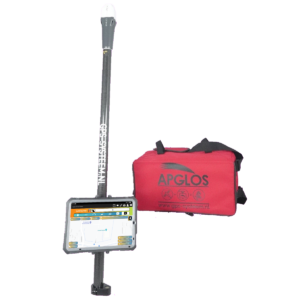
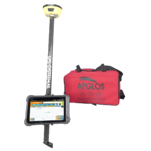
All GPS measuring sticks on this website are professional surveying systems for measuring with GPS.... With the GPS measuring systems on this website you get the same accuracy that of any surveyor.
Nevertheless, the GPS measuring sticks rented and sold on this website are easy to use. Before the GPS measuring system is delivered to you, it is already fully set up. In addition, all of our GPS measuring systems include the easiest-to-use surveying software.
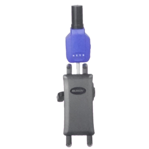
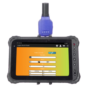
This is Apglos Survey Wizard. Should you wish to download only the software you can do so via the Google Play Store. After downloading and registering, you can test this easy-to-use surveying application for free.
How does surveying with GPS work?
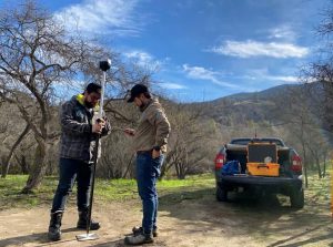
You probably see a man standing next to the road quite often with a GPS measuring stick. That is a pole with a GPS receiver. This person is then probably measuring with GPS.
With a level instrument, another surveying instrument, it is easier to understand how it works. This is because with a level instrument, one looks through a lens at a staff. And from the scale bar on the staff, one can read the data.
This is different with GPS. GPS stands for Global Positioning System. In normal Dutch, that is Globaal Positioning System. That ultimately says that one can determine one's position all over the world.
And that, in turn, is possible because there are many satellites flying around the world, sending a signal with where the satellite is at the time.
The GPS receiver of the GPS measuring stick receives these signals. Based on the received satellite signal, the receiver can determine the distance (R) between the satellite and the GPS receiver. With sufficient satellite signals, the GPS Receiver can determine the exact position. Among other things, the GPS Receiver does this with the formula:
X2+Y2+Z2=R2
But that's all the math I want to report here. So based on this position, GPS can be used to measure in.
Is GPS surveying difficult?
GPS surveying may seem difficult because of what I described above. That's probably because of the word math. But all the math is done in the GPS receiver and therefore GPS surveying requires little math or surveying calculations anymore.
Actually, to survey with GPS, all you have to do is turn on the GPS receiver and the tablet and you can start. This is certainly the case when you start surveying with Apglos Survey Wizard.
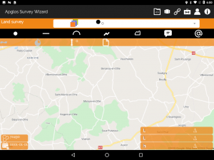
With a few simple buttons you control the software and can quickly and easily capture points, lines, arcs, polylines and planes.
All GPS surveying systems on this website come with this simple land surveying software Apglos Survey Wizard and and are fully pre-set so you can start surveying right away.
Where can you measure with GPS?
As indicated, the GPS receiver needs satellite signals to determine its position. Theoretically, the GPS receiver can determine position using signals from four different satellites. But often, due to variations in the atmosphere, around 8 satellites or more are often needed to determine the position exactly.
And that is really the only requirement for surveying with GPS. The GPS receiver must receive enough satellite signals. Now there are more and more satellites in space orbiting the earth, sending position data.
This is good because it makes it easier and easier for the GPS receiver to get enough satellite signals and allows GPS measurements to be made in more and more locations.
Actually, GPS surveying can be done anywhere as long as there are enough satellite signals. In the following locations, the lack of satellite signals usually prevents the use of GPS:
- In buildings
- Under overpasses and bridges
- In tunnels
There are also other conditions that can make it difficult for the GPS receiver to receive enough satellite signals. Examples include:
- under trees
- near tall buildings
- with reflective surfaces
However, the techniques of GPS receivers and the amount of satellites transmitting position data is increasing. As a result, it is becoming easier and easier to measure in with GPS.
The firmware of the GPS receivers on this website is regularly updated. As a result, the GPS receivers have the latest technology developed by the manufacturer.
Can one measure GPS with a phone?
Of course, a phone also has a GPS on it. Using the GPS on the phone one can navigate, among other things. However GPS surveying is not quite the same as navigating with GPS.
The accuracy of the GPS on the phone is around 10 m. This means that there is a large deviation. While navigating, this is acceptable and permissible.
However, this is slightly different with GPS surveying. As everyone knows: measuring is knowing. But if there is a deviation of about 10 meters, the results are not exact and measuring is knowing.
Therefore, GPS surveying equipment is called some things that a phone does not use. First, GPS surveying equipment has a larger antenna, which is inside the GPS receiver. A larger antenna makes it easier for the GPS receiver to receive the satellite signals than for a phone.
In addition, one attaches the GPS receiver to a GPS measuring stick. This also allows one to determine the exact altitude. The stick or lead rod also raises the GPS receiver higher. As a result, there is less interference with the satellite signals than with a telephone and, therefore, a more accurate position can be determined.
In addition, a GPS receiver contains a more powerful ‘computer’ than a phone. This allows the position to be determined faster and better.
Furthermore, a GPS receiver can handle corrections, such as (RTCM), and a phone cannot. This makes GPS surveying with a phone much less accurate than with a professional GPS system from this website.
If you would like to learn more about GPS surveying with a phone check out this video.
When to hire a surveyor and when to measure yourself with GPS?
With a GPS measuring system you can measure yourself with GPS. And so you will get the same results as a surveyor. Still, for some situations it can be convenient to hire a surveyor.
So this may be when some part of the surveying cannot be done with GPS, such as in a tunnel. Also for measurements, where accuracy is of great importance, it may be wise to hire a surveyor.
The latter may be the case when plotting buildings. This is often done with a total station.
But beyond that, there are few projects you could not measure yourself with GPS. In addition, surveying yourself with GPS has a number of advantages over hiring a surveyor.
First, when you survey yourself with GPS, you have full control over the schedule of surveying. When you hire a surveyor, you are dependent on the surveyor's schedule, which is not always convenient.
In addition, you decide what you measure with GPS. When you hire a surveyor, information can be lost due to communication, so not everything is measured. As a result, the quality of a surveyor's measurement is not always equal to your expectations.
Finally, of course, there is the cost. The price of GPS surveying equipment is currently such that it is more economical to survey with GPS yourself than to hire a surveyor.
So the balance between hiring a surveyor and surveying yourself with GPS is tilting more and more toward surveying yourself with GPS.
Where can you buy equipment for GPS surveying?
This is actually the simplest question. Equipment to measure in with GPS is best bought on this page. There you will find a good quality GPS measuring system at a good price.
If you would like a demonstration you can request one on the same page.
Even though the GPS measurement systems on this website have a good price, it is still an investment. And for that amount, you may prefer to try a GPS measurement system first. That too is possible with us. Take a look at this page.
After the trial period, you can decide whether GPS surveying is for you and whether it will add value to your projects.
 Want to schedule a demo? You can do that through whats!