
GPS Measurements in the Woods: Which Antenna Works Best?
GPS Surveying in the Forest: Why, in our experience, a flat survey antenna provides more stable RTK measurements in dense Swedish forests.

GPS-System.se is a partner of Apglos B.V. (Netherlands). Apglos B.V. is developer of the easiest land surveying software for Android and iOS.
Apglos Survey Wizard is the simplest handheld surveying software for non-surveyors.
This is Apglos Survey Wizard.


With this surveying software, anyone can survey and stake out. Apglos Survey Wizard therefore forms the basis of all GPS surveying systems on this website.
GPS Surveying in the Forest: Why, in our experience, a flat survey antenna provides more stable RTK measurements in dense Swedish forests.
Measuring with a GPS measurement system is easy. Yet taking the first step can be tricky. That's why we have some video instructions for
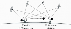
How does RTK work? RTK stands for Real Time Kinematic. It means being able to provide centimeter-accurate position of a moving object all the time.