An elevation survey is a common part of surveying. Although the Netherlands is known to be flat, there are many differences in elevation. These height differences are mapped with an elevation measurement.
An elevation survey involves measuring the height differences of a terrain. The easiest method is to perform the height measurement with GPS, but it can also be done by levelling, with a total station or with a drone. By properly mapping the height differences by means of an altitude measurement, bottlenecks related to the height can be quickly and properly resolved.
To make everything clear on this topic, we will answer the following questions in this article:
- Why is a height measurement important?
- How does a surveyor perform a height measurement?
- Is altitude measurement with GPS the easiest way for an altitude measurement?
- What is a good altitude measurement app?
Height measurement: the solution
You may not have the opportunity to read this entire article. Therefore, there is another opportunity to learn more about height measurement.
You can try a GPS measurement system through this website. And with our GPS measurement systems you can perform a measurement. For that, look directly at this page.
You can request a demonstration of one of our GPS surveying systems on the same page. At this demonstration you can then also ask specific questions about height measurement and of course about other topics related to GPS surveying.
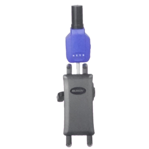
If you don't have time for a demonstration or want to quickly try the software of our GPS measurement systems in between, that is possible. Apglos Survey Wizard is the easiest software to carry out GPS measurements, including an altitude measurement. You can download it for free from the Google Play Store.
The surveying app Apglos Survey Wizard has full functionality with your Android device's GPS. So you can fully test this app and it is free.
Of course, the accuracy of our GPS receivers is better than that of standard Android devices. So if you want to test with an accurate system, check out this page.
Why is a height measurement important?
As already described, height measurements are often performed in the Netherlands. These kinds of measurements are therefore very important.
Many people think the Netherlands is flat, but that is not entirely true. There are many height differences in the Netherlands. Consider a watercourse. The top of a watercourse is higher than the bottom.
When one wants to build a new project, of course, it must match the adjacent land in terms of height. For this, the heights of the adjacent land must be known. And that is why height measurements are carried out.
Based on the heights of the adjacent land one can determine the level of the project. When one then performs a height measurement of the project site one can also determine how much soil to excavate and/or backfill.
However, it is not just the amount of elevation that makes the type of elevation measurement important. No, there is another factor, which causes many heights to be measured in the Netherlands. And this factor is the amount of precipitation, which falls in the Netherlands.
The rain that falls in the Netherlands does not all infiltrate directly into the ground. When rain falls on pavement, it flows to the lowest point. Improper design can cause flooding.

To minimize the risk of flooding, the elevations must be properly mapped. Only when that has been done can a proper design be made to prevent flooding.
The main reasons for performing a height measurement are:
- connecting to adjacent areas
- prevention of nuisance
- calculate quantities of soil to be excavated and/or backfilled
How does a surveyor perform a height measurement?
So one of the tasks of a surveyor is to take elevation measurements. The surveyor can do this in several ways.
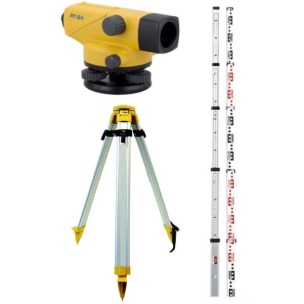
An old but still widely used method is by using the spirit level instrument. Leveling involves two people. One holds the staff and the other reads the height through the level instrument. This method of taking a height measurement does require knowing the height of a fixed point. Also, only the height is determined and not the x and y coordinates.
Another way for a surveyor to take an elevation measurement is with a total station. Using angles and distances, a total station can determine all positions in a given field. To do this, however, the total station needs some coordinates of known points. In principle, very accurate measurements can be made with a total station. However, this is highly dependent on how the known points are determined. If the known points have been determined with GPS, then an altitude measurement with a total station will be no more accurate than when performed with a GPS measurement system.
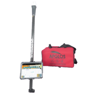
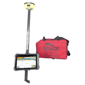
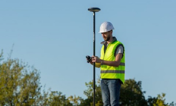
And then we come to a commonly used method for taking elevation measurements. This is with a GPS system. An elevation measurement with a GPS measuring system can be done independently by one person. The accuracy of a GPS system is somewhat better in the horizontal plane and somewhat less for determining elevation. Still, the accuracy of a GPS system in elevation is about 2 cm. And that is more than sufficient for most purposes. Another advantage for height measurement with a GPS system is that one can mount the GPS system on a quad, for example. In this way, one can quickly perform a height measurement of a terrain.
For large sites, a surveyor often performs elevation measurement with a drone. A drone can fly over the terrain and collect untold numbers of points. While it is faster, it does have a greater deviation than the other three methods of taking an elevation measurement. A height measurement with a drone can give as much as a 10-cm deviation.
Is altitude measurement with GPS the easiest way for an altitude measurement?
As you can read, there are several methods of performing an altitude measurement. The easiest method is certainly with GPS. With one of our GPS measurement systems, you can also perform height measurements yourself.
It is not difficult. This is in contrast to the other methods. Leveling is not complicated either, but it does require two people and some arithmetic. And even if you are the best calculator, a miscalculation is easily made. And a miscalculation leads to wrong heights with levels.
To work well with a total station, one must have learned a thing or two about it. It is not that simple. And it requires precision.
Working with a drone requires yet other capabilities. One must be able and allowed to fly a drone. This, too, is not for everyone.
Unlike the other methods of performing an elevation measurement, that with GPS is accessible to everyone and can be mastered quickly by anyone. This is especially true if the height measurement is carried out with one of our GPS measurement systems, as all of our GPS measurement systems are equipped with the simplest surveying app.
Read more about altitude measurement with GPS here.
What is a good altitude measurement app?
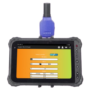
And so that brings us directly to what a good altitude measurement app is. And so that's the surveying app that comes with our GPS surveying systems. That's Apglos Survey Wizard. You can download it for free from the Google Play Store.
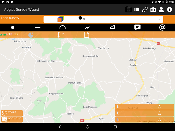
As an elevation survey app, Apglos Survey Wizard has many advantages. First, it is easy to use.
In addition, when you use the proper settings, Apglos Survey Wizard works with NAP elevations. In fact, Apglos Survey Wizard converts GPS coordinates to RD coordinates and a NAP elevation.
So this is certainly not true for all height measurement apps. And working with NAP heights in the Netherlands is important because then you can compare the measured height with other already known heights.
However, it is important to connect the Apglos Survey Wizard altimetry app to an external GPS receiver. Although Apglos Survey Wizard also works with the GPS of an Android phone or an Android tablet, the accuracy of the GPS modules in these devices is not as high.
Therefore, the reliability of the measurement is not high. However when you connect the height measurement app Apglos Survey Wizard with external GPS receiver then you can take height measurement with centimeter accuracy. And that is why Apglos Survey Wizard is the best height measurement app.
Final conclusion on height measurement
This was a whole article on altimetry. There is a lot to report on this topic of GPS surveying. So we hope that you have picked up at least a few things from it and can take advantage of them.
However, everything written in this article is theory. If you want to put this theory into practice you can.
In fact, you can try or buy a GPS measurement system through this website. When you do so then you can immediately put into practice what you have learned by reading this article on height measurement. And you can see if working with our GPS measuring equipment is something for you.
Of course, when you try or buy one of our GPS measurement systems, you will receive a short and clear explanation so that you can get started with it right away.
If you would like a demonstration first, you can also request one through the pages mentioned above. With a demonstration or a brief explanation you can also ask specific questions about height measurement.
 Want to schedule a demo? You can do that through whats!