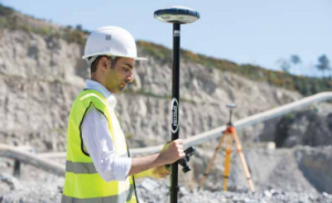
Measuring with GPS is a common activity on every construction site these days. Whether it is an infrastructure project or any other type of construction site the following rule always applies: Measuring is Knowing.
Measuring with GPS is the recording of points, lines, arcs and other elements based on position determined from satellite signals. Before the era of GPS measurement, surveying was mainly a task of surveyors. However, in the GPS era, measuring has become accessible to everyone. Capturing elements by measuring with GPS has become easier, especially when done with the surveying application Apglos Survey Wizard.
On all construction projects, GPS measurements are important. Yet many companies still outsource this to surveyors. That's because measuring with GPS seems difficult for many companies. That's not necessary. It is probably easier than you think. Therefore, here are the answers to the following questions:
- What are the advantages of measuring with GPS?
- How can one measure distance with GPS?
- Can one also measure altitude with GPS?
- How easy is it to measure and plot with GPS?
- Where can you buy equipment to measure with GPS?
Buy or try GPS measuring equipment directly
You may not want to read this entire page, but are already looking for equipment to measure GPS. Even then you have come to the right place. On this website you can buy or rent a good, complete GPS measuring system. If that is still a step too far, you can request a demonstration on these pages. Then you can see whether measuring with GPS is something for you.
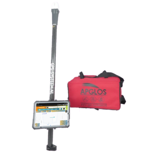
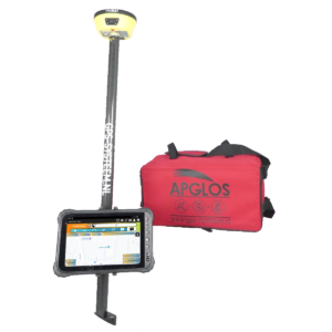
All GPS measuring sticks on this website are professional surveying systems for measuring with GPS. With the GPS measuring systems on this website, you will get the same accuracy that of any surveyor.
Nevertheless, the GPS measuring sticks rented and sold on this website are easy to use. Before the GPS measuring system is delivered to you, it is already fully set up. In addition, all of our GPS measuring systems include the easiest-to-use surveying software.
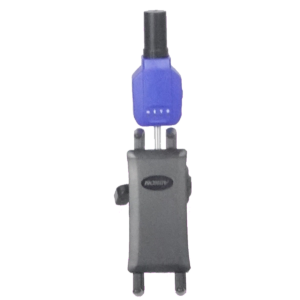
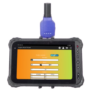
This is Apglos Survey Wizard. Should you wish to download only the software you can do so via the Google Play Store. After downloading and registering, you can test this easy-to-use surveying application for free.
What are the advantages of measuring with GPS?
There is actually one big advantage of measuring with GPS. And from that advantage actually come all the other advantages. This big advantage is that measuring with GPS is much easier than any other form of surveying. In the end, it is nothing more than turning on the GPS measuring system. Then all you have to do is press the button when you are at the point you want to record.
Of course, much more can be done with our GPS measuring equipment. But in the end, measuring with GPS always comes down to the above.
So measuring with GPS is easy. As a result, anyone can perform it. And benefits flow from that.
Therefore, when measuring with GPS yourself, one can decide what and when to measure. This is a huge advantage because it increases the quality of construction projects and also allows more control over the planning. In both cases, you are no longer dependent on the surveyor.
And while a surveyor will always do their best, it is a very nice feeling when you know you are in control of an essential part of the construction project, measuring and plotting.
In addition, there is another advantage. When you measure yourself with GPS, you need to hire fewer surveyors. In the long run, you will always be more economical as a result. This is because when you purchase a GPS measurement system, you can view it as an investment. You can also use the GPS measuring equipment again on a project in the future.
However, you hire a surveyor only for the work he performs on the project. On new projects, you will incur the same costs again. And so that is something you can save on by measuring yourself with GPS.
How can one measure distance with GPS?
With GPS measuring equipment, it is possible to measure distance. The distance is then determined by the software Apglos Survey Wizard between two points captured by the GPS measurement system. This, too, is simple.
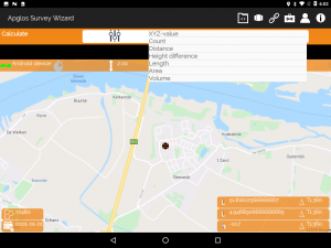
In the land surveying software Apglos Survey Wizard there is a separate calculation module that is easy to use. By selecting two points, you can use this module to measure the distance. The distance is thus easy to determine with a GPS measurement system.
Inside the GPS receiver and in surveying app Apglos Survey Wizard, of course, much more happens. You don't see so much of it, but a huge number of calculations are performed. Because this all happens automatically, it is now also easy to measure with GPS. You only have to indicate what you want to do and the software Apglos Survey Wizard makes sure you get the data you ask for.
So in this case, the distance between two points. This, of course, is easily defined. And it's easy to say that measuring distance with GPS is easy, but of course you can try it yourself by using Apglos Survey Wizard from the Google Play Store. download.
You can try it yourself. And then you will find out that it is easy.
Of course, Apglos Survey Wizard's calculation module includes other calculation functions. For example, one can determine the length. In addition, one can also determine area and volume. When you download the surveying app you can try out all these functions.
Can one also measure altitude with GPS?
GPS stands for Global Positioning System. This means that position can be determined all over the world. And a position generally has three factors. There are, of course, latitude and longitude. In addition, there is altitude.
However, the Netherlands works with x, y and z. Apglos Survey Wizard converts the latitude, longitude and altitude via the RDNAPTRANS2008 transformation or via the RDNAPTRANS2018 transformation to an x, y and z value.
The x and y values represent the horizontal position, which one can project onto a map. The z value is the height of the position.
So yes, one can measure altitude with GPS.
Yet that is not all. With GPS, the elevation of a point is more difficult to determine than the x and y coordinates. Although much calculation is done in the GPS receiver, the deviation in elevation is often greater than in the horizontal plane.
Of course, this is reduced as much as possible, by correction signals, among other things. But the height deviation is often 1.5 to 2 times greater than the deviation in the horizontal plane.
Nevertheless, GPS measurement equipment can determine height with an accuracy of about 2 to 3 centimeters. And for most applications, that is an accuracy that is more than sufficient.
So really, the answer to the question of whether one can measure altitude with GPS should be slightly modified. The actual answer should be:
Yes, one can measure altitude with GPS, but be aware that when using the results, the altitude measurements may have a slight bias.
How easy is it to measure and plot with GPS?
Measuring with GPS is easier than with a level instrument, a total station or a theodolite. However, because of these surveying instruments, GPS measuring still has a bit of a delusion about it being difficult.
However, the opposite is true. Measuring and plotting with GPS is not difficult. In fact, it is easy. The reason is that when everything is set up that all you have to do is turn on the GPS measuring equipment and you can measure.
Now there are certainly a number of settings when using GPS measurement equipment. These include the coordinate system, connecting to the GPS receiver and NTRIP data, for example.
However, our GPS measuring systems are all preset, so there is the case for you that you only need to turn on the GPS measuring equipment and then you can immediately measure and plot with GPS.
The GPS surveying systems on this website are certainly easy to work with. In addition to the preset equipment, our surveying systems also come with the easiest to use surveying software. This is Apglos Survey Wizard.
Apglos Survey Wizard has a number of features to help you work with GPS survey equipment. If you don't know what you want to do, you can choose a guided tour for a specific function. Apglos Survey Wizard will then guide you through the program focused on the function you want to perform. This eliminates the need to go through an entire manual.
Of course, there is a manual of the land surveying application Apglos Survey Wizard. And this manual can be accessed directly from this surveying application. In the manual, you can read all about Apglos Survey Wizard. This is always useful when you want to know even more about the app. This will allow you to work even more effectively with our GPS surveying equipment.
In addition, there are videos in Apglos Survey Wizard. When something happens other than what you probably expected, you get a notification if you want to see an explanation video about the particular feature. As a result, the learning curve is incredibly small and you will quickly find yourself using the Apglos Survey Wizard surveying application.
If it does not work at all then there is even the possibility to send a message to the developers via the app. You will then receive an email back as soon as possible with an answer to your question, so you can get back to measuring quickly.
The conclusion, then, is that measuring and plotting with GPS is easy as long as you do it with a GPS measurement system that integrates Apglos Survey Wizard.
Where can you buy equipment to measure with GPS?
This is actually the simplest question. Equipment to measure with GPS is best bought on this page. There you will find a good quality GPS measuring system at a good price.
If you would like a demonstration you can request one on the same page.
Even though the GPS measurement systems on this website are priced right, they are still an investment. And for that amount, you may prefer to try a GPS measurement system first. That too is possible with us. Look at this page for that.
After the trial period, you can decide whether measuring with GPS is for you and whether it will add value to your projects.
 Want to schedule a demo? You can do that through whats!