GPS definitions from A to Z. Within GPS there are many different terms, which are used. On this page I have collected them all for you, so you have a total overview with all GPS definitions.
GPS, or Global Positioning System, was coined in the United States. Consequently, many terms are in English. Fortunately, you do not need to know English to use GPS. Moreover, this list of GPS definitions clearly describes all GPS terms, so you also have a good idea of the background of GPS.
GPS definitions: the solution
You may not have the opportunity to read this entire article. Therefore, here is another opportunity to learn more about GPS and its definitions.
You can try a GPS measurement system through this website. To do so, look directly at this page.
You can also request a demonstration of one of our GPS surveying systems. At this demonstration you can also ask specific questions about the different GPS definitions and of course about other topics related to GPS surveying.
If you don't have time for a demonstration or want to try the software of our GPS measurement systems quickly in between, that is possible. Apglos Survey Wizard is the easiest software to perform GPS measurements with. You can download it for free from the Google Play Store.
The surveying app Apglos Survey Wizard has full functionality with your Android device's GPS. So you can fully test this app and it is free.
Of course, the accuracy of our GPS receivers is better than that of standard Android devices. So if you would like to do a test with an accurate system, check out this page.
Flattening
Flattening is a value for the ratio of the horizontal radius to the vertical radius of an ellipsoid. An ellipsoid is often used as a model of the Earth.
Distance
Distance is a quantity, used in mathematics, to denote the measurable space between tween non-coincident objects. In GPS surveying, it is especially important when plotting to reduce the distance to zero so that you can mark the location of the point to be plotted.
Altitude
Altitude is the difference in altitude between the object and a certain reference level. In the case of GPS surveying, the reference level is the ellipsoid.
Antenna
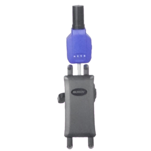
An antenna is the part of GPS measurement system, which receives satellite signals. An antenna can be integrated into a GNSS receiver, or it can be completely external. Not every antenna can receive the same satellite signals. When putting together a GPS measurement system, it is important to carefully consider which satellite signals the GPS can receive.
Base station (Base)
A base station is a GNSS receiver at a fixed location, which receives satellite signals over a long period of time, and can therefore send correction signals to other GNSS receivers so that these GNSS receivers can determine exact position.
BEIDOU
BEIDOU is the Chinese satellite constellation for navigation, or the Chinese counterpart of GPS. So this is a system of Chinese satellites, which send signals to Earth so that receivers can determine exact position. Most receivers work with both GPS and BEIDOU.
Bipod
A bipod is a GPS tool, consisting of two legs, that allows a GPS measuring stick to be held upright so that it can determine position in one and the same place for a longer period of time.
Bluetooth
Bluetooth is a short-range communication protocol between devices. It allows data to be transmitted between different devices. Most GNSS receivers use Bluetooth to communicate calculated position data to other devices.
Arch
An arc is a line element with a curve. In addition to the starting and ending points, the radius largely defines what the arc looks like. Apglos Survey Wizard allows you to measure arcs.
Latitude
Latitude is the latitude. Latitudes run parallel to the equator. The maximum value is at the north pole by 90˚. And the minimum value is at the south pole by -90˚. Right in the middle is the equator. This has a value of 0˚. A GPS position is indicated in a latitude and a longitude.
Cassini-Soldner
Cassini-Soldner is the name of a way to convert a coordinate with latitude and longitude to an X and Y coordinate, so that the point can be projected on a map. In the Netherlands and Belgium, this method is not used.
CORS
CORS stands for continuously operating reference stations, or continuous reference stations. This is a network of GPS receivers, at a fixed location, that determine position all the time and detect deviations from the satellite signals. These deviations are corrected and the corrections are sent to the GPS receivers in the field.
CRS
CRS stands for Coordinate Reference System. So this is basically how and with what coordinates a point is projected on a map. In the Netherlands, this is the Rijksdriehoek system with the well-known RD coordinates. In Belgium, several CRS are used, such as Lambert72.
Date
A datum is a model of the earth used to map objects. This model consists mainly of two values. One value is for the radius of the earth and the other value is for the oblateness.
DGPS
DGPS stands for differential global positioning system. When this is applied, the receiver's position is corrected using data from a reference receiver. This improves the position calculation of the receiver. DGPS achieves an accuracy of about 2 to 5 meters.
Differential correction
Differential corrections are the corrections GPS receivers use to calculate position more accurately.
Easting
Easting is an English term for the value of a point from west to east. In the Netherlands and Belgium, the term X-coordinate is often used for this purpose.
Eccentricity
The eccentricity indicates how flattened an ellipsoid is. Eccentricity and flattening are both values that indicate the relationship between the horizontal and vertical radii of an ellipse.
ECEF
ECEF stands for earth-centered, earth-fixed. This is a coordinate system whose zero point is the central point of the earth. The coordinates are denoted in an X, Y and Z coordinate. ECEF is used in some cases to convert a coordinate of latitude, longitude and altitude to an X, Y and Z coordinate for use on a map.
EGNOS
EGNOS stands for European Geostationary Navigation Overlay Service. This is the European SBAS to improve the operation of the complete GPS system in Europe.
Ellipsoid
An ellipsoid is a model of the Earth in the shape of an ellipse. The circumference around the north and south poles is smaller than the circumference around the equator. Some important ellipsoids in the world of GPS are WGS84 and ETRS89.
Epoch
Epoch represents a base time. From this particular time, the satellites calculate so that they deliver the correct signal.
ETRS89
ETRS89 is the model of the earth used in most of Europe. ETRS89 is a model in the shape of an ellipsoid. The radius around the earth is 6378137 and the oblateness denoted in the term 1/f = 298.257222101. This is the basis of all GPS measurements in Europe.
Equator
The equator is an imaginary line at the widest part of the earth. This line separates the northern hemisphere from the southern hemisphere, and the latitude or latitude here is 0˚.
Float RTK
Float RTK is a value for the accuracy of the calculated position. Using data from reference receivers, the position is calculated more accurately. When the accuracy is between about 1 meter to 0.10 m then the position is indicated by the accuracy value Float RTK.
Galileo
Galileo is European satellite constellation for navigation. This is the European equivalent of GPS. These European satellites also send positioning data to Earth, allowing receivers to determine position. Most receivers work with both GPS and Galileo.
Geoid
A geoid is a hypothetical model of the earth, where the sea level is the same. When measuring with GPS, the altitude must be corrected to one level. This is because the earth's gravity is not the same everywhere. When determining heights with GPS, these heights must be corrected so that the difference in gravity is nullified.
GGA
A GGA rule is part of the NMEA rules, which a normal GPS receiver sends to communicate its position. The GGA line contains the exact position of the receiver in latitude and longitude. In addition, there is data in this line that can be used to determine the altitude. Below is an example of a GGA rule.
$GPGGA,172814.0,3723.46587704,N,12202.26957864,W,2,6,1.2,18.893,M,-25.669,M,2.0,0031*4F
This line also states the fix or accuracy value. This can be DGPS, Float RTK, RTK.
GLONASS
GLONASS is the Russian GPS. After the Americans launched GPS, the Russians could not be left behind. They also launched navigation satellites. All these Russian navigation satellites together are called GLONASS. Most receivers work with both GPS and GLONASS.
GNSS
GNSS is the abbreviation for Global Navigation Satellite System. When after the Americans the Russians launched their navigation satellites, there were several satellite constellations for navigation. The name for all navigation satellites together is GNSS. In addition to GPS and GLONASS, this includes BEIDOU and GALILEO.
GNSS receiver
A GNSS receiver is a receiver, which can determine a position from different navigation satellites. For a GNSS receiver, these can be satellites from the various satellite constellations GPS, GLONASS, BEIDOU and GALILEO.
GPS
GPS stands for Global Positioning System. It is the name for the U.S. constellation of navigation satellites. These satellites send position data to the earth, allowing the receiver to determine its exact position on earth.
GPS receiver
Officially, a GPS receiver only determines its position using satellite signals from GPS satellites. However, the terms GPS and GNSS are often used interchangeably. This is why a GNSS receiver is often referred to as a GPS receiver. This is in fact not correct.
Greenwich
At Greenwich, a town in England, lies the meridian, which is considered the zero point of longitude or longitude. This meridian is not only the beginning of the longitude count, but also the end. And then this meridian has a value of 360˚.
GST
A GST rule comes from the NMEA rules, which are sent by normal GNSS receivers to share position data with other devices. The GST rule contains position accuracy data. An example of a GST rule is shown below.
$GPGST,172814.0,0.006,0.023,0.020,273.6,0.023,0.020,0.031*6A
Handheld
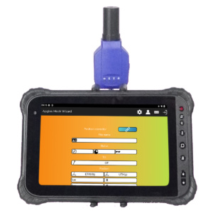
A handheld is a part of a complete GPS measurement system, where work is done with the position determined by the GNSS receiver. This can be storing the coordinate or surveying or plotting points. Some forms of handhelds are tablets or phones.
hBG18
Almost every country uses its own geoid. In Belgium, the geoid hBG18 is used. It is needed to translate the latitude determined by GPS into a TAW altitude.
HDOP
HDOP is the abbreviation for Horizontal Dilution of Precision. This value indicates how scattered the positions of the satellites are and how certain or uncertain the horizontal position can be determined with it. The more scattered the satellites are the more certain the GNSS receiver can determine the position.
Height bolt
A height bolt is a bolt placed by someone with a certain height. This height is known, allowing one to verify measurements. There are also height bolts managed by the Land Registry. These are measured and checked every few years.
Hotine Oblique Mercator
Hotine Oblique Mercator is the name of a way to convert a coordinate with latitude and longitude to an X and Y coordinate, so that the point can be projected on a map. In the Netherlands and Belgium, this method is not used.
Hotine Oblique Mercator Azimuth Center
Hotine Oblique Mercator Azimuth Center is the name of a way to convert a coordinate with latitude and longitude to an X and Y coordinate so that the point can be projected on a map. In the Netherlands and Belgium, this method is not used.
Surveying
Surveying is the recording of objects in the form of points, lines, arcs and planes so that a map or surface can eventually be made from them.
Map projection
A map projection is an image of (part of) the Earth's surface in two dimensions. To do this, the latitude and longitude of the earth must be converted to an X coordinate and a Y coordinate. This can be done in many ways, such as with:
- Cassini-Soldner
- Hotine Oblique Mercator
- Hotine Oblique Mercator Azimuth Center
- Krovak
- Lambert Conic Conformal (1SP)
- Lambert Conic Conformal (2SP)
- Mercator (1SP)
- Mercator (2SP)
- Oblique Stereographic
- Polar Stereographic
- Transverse Mercator
- Transverse Mercator South Orientated
Krovak
Krovak is a method of projecting the points of the earth's surface onto a flat image. This method is not used in the Netherlands and Belgium.
L1
L1 is the oldest signal emitted by GPS satellites. This signal uses the frequency 1575.42 MHz. Any GNSS receiver will be able to receive this type of signal.
L2
L2 is an enhanced signal of the L1 signals. It uses the frequency 1227.60 MHz. This signal is faster, so it also passes through clouds, buildings and trees more easily. Not every GNSS receiver uses this signal to determine position.
L5
Meanwhile, there is also the L5 signal. This signal is also provided by GPS satellites. This signal uses the frequency 1176 MHz. This will work even better than the L2 signal. Not all GNSS receivers will be able to use this signal.
Lambert Conic Conformal (1SP)
Lambert Conic Conformal (1SP) is a method of converting a latitude and longitude coordinate to an X coordinate and a Y coordinate so that it can be projected onto a flat surface or map.
Lambert Conic Conformal (2SP)
Lambert Conic Conformal (2SP) is a slightly different method than Lambert Conic Conformal (1SP). But it too is a method for converting position in latitude and longitude into an X and Y coordinate.
Lambert 2005
Lambert 2005 is the coordinate system in Belgium introduced by the Belgian National Geographic Institute in 2006. This coordinate system was quickly replaced by Lambert 2008 and should no longer be used.
Lambert 2008
Lambert 2008 is the replacement for Lambert 2005. This coordinate system was introduced in Belgium in 2007. This was done by the National Geographic Institute. This coordinate system was introduced to improve and speed up data collection with GPS.
Lambert 72
Lambert 72 is another coordinate system in Belgium. This has been an official coordinate system in Belgium since the mid-1970s. It is still in use today.
Survey app
A surveying app is software on a tablet, phone or handheld that allows one to perform surveying activities, such as surveying and stakeout. A surveying app is therefore an essential part of GPS surveying equipment.
Land surveying software
Land surveying software is part of a complete GPS surveying system. It is installed on the handheld. Using the surveying software, one can measure and stake out.
Latitude
Latitude is the position from north pole to south pole, which is given in degrees. The north pole here is 90˚ and the south pole here is -90˚. At exactly 0˚ is the equator.
Length
Length is the dimension of an object between its starting and ending points.
Longitude
The longitude is the position on the earth in a west-east direction. Where the 0 meridian at Greenwich is the zero point and the value eastward increases to 360˚ until one reaches Greenwich again. Sometimes the western hemisphere is also indicated by the values -180˚ to 0˚.
Line
A line is the shortest route between two points.
Longitude
Longitude is the position of a point in an easterly direction. The zero point of longitude is the 0 meridian at Greenwich. From there, longitude rises in an easterly direction until it reaches the meridian at Greenwich again to a value of 360˚. Sometimes the western hemisphere is also indicated by the values -180˚ to 0˚.
Lead rod
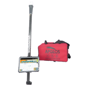
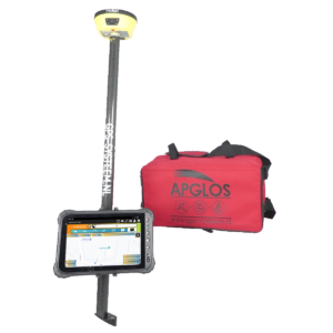
A lead rod is part of a GPS measurement system. The GNSS receiver is mounted on top of the pilot rod and the handheld or tablet attached to it. This makes it easy to hold the lead rod with one hand and operate the surveying software with the other. It is important to know the length of the pilot rod because the height of the GNSS receiver location affects the measured position.
Lora
Lora stands for Long Range. This is primarily a term used when using a private base station. The correction data is then sent from the base station to the rover by radio. Lora antennas are often used for this purpose.
Magnetic north
Magnetic north is where compasses point to. This is not quite the same as true north, which is used in GPS.
Measuring stick
A measuring stick in the world of GPS is the complete GPS system needed to measure. This includes the GNSS receiver, lead rod, tablet holder, tablet and surveying software.
Mercator (1SP)
Mercator (1SP) is a method of converting a latitude and longitude coordinate to an X coordinate and a Y coordinate so that it can be projected onto a flat surface or map.
Mercator (2SP)
Mercator (2SP) is a slightly different method than Mercator (1SP). But it too is a method of converting position in latitude and longitude into an X and Y coordinate.
Meridian
A meridian is an imaginary line from the north pole to the south pole, indicating from west to east a position on the earth in degrees, or longitude.
MSL
MSL is an abbreviation of Mean Sea Level. This is the vertical level often referred to as the elevation level in GPS.
Multipath
Multipath is the GNSS receiver receiving two different signals from a navigation satellite at the same time. This can occur due to reflection of the signal through windows, etc.
NAP
NAP stands for Normal Amsterdam Level and is the Dutch reference level. In the Netherlands, relative to this level, the heights of. Read more about NAP here.
NLGEO2004
In order to use GPS to determine elevations in NAP, the measured GPS heights must be corrected with a geoid. This was done with the geoid called NLGEO2004. Meanwhile, this geoid has been replaced by NLGEO2018.
NLGEO2018
The heights measured with GPS are corrected to NAP heights in the Netherlands using the geoid NLGEO2018. This allows new measurements to be compared with the old heights.
NMEA
NMEA is an abbreviation for National Marine Electronics Association. This is the most common language GNSS receivers use to communicate their position data with other devices. The most commonly used protocol is NMEA 0183. This protocol also describes the GGA and GST rule.
Northing
Northing is an English term for the value of a point from south to north. In the Netherlands and Belgium, the term Y-coordinate is often used for this purpose.
NTRIP
NTRIP is another abbreviation. It stands for Networked Transport of RTCM via Internet Protocol. This is the protocol of how communication occurs between a network rover and a network of reference stations.
NTRIP caster
An NTRIP caster is part of the correction network, which collects the data from all reference stations in the network and sends the correct data from them to the network rover.
NTRIP client
An NTRIP client is a network rover, which sends its position to the NTRIP caster and requests correction data. After receiving this correction data, the NTRIP client can determine its position more accurately.
NTv2
NTv2 is a grid of correction values. The term stands for National Transformation version 2. In some map projections, these grid corrections are necessary to properly fit the GPS coordinates to a two-dimensional drawing. This is mainly due to deformations that the earth has, which were not taken into account when the coordinate system was created at the time. NTv2 files are used in both the Netherlands and Belgium.
Oblique Stereographic
Oblique Stereographic is a method of projecting the obtained GPS coordinates onto a flat surface or map. Thus, this method can be used to determine X and Y coordinates.
Surface
Surface is the size of a closed two-dimensional geometric object.
Pole Point
A pole tip is the standard base of the lead rod. Using the tip, objects can be precisely probed, allowing for more precise GPS measurements.
PDOP
PDOP is the abbreviation for Position of Dilution of Precision. This value indicates how dispersed the positions of the satellites are and how certain or uncertain the position can be determined with it. The more scattered the satellites are the more certain the GNSS receiver can determine the position. PDOP is a combination of HDOP and VDOP.
Picket
A picket is a wooden post that shows the position of a plotted point. By using stakes when plotting, one can easily find them again and easily construct or build the design in the correct location.
Polar Stereographic
Polar Stereographic is the name of a way to convert a latitude and longitude coordinate to an X and Y coordinate so that the point can be projected on a map.
Polyline
A polyline is a line element consisting of multiple line segments. A polyline may contain several kinks. This type of line element is often used in CAD programs.
Postprocessing
Postprocessing is the process, in which the bare GPS data is compared with the data from a reference station after the measurement is completed, thus correcting the acquired data to accurate results afterwards.
PPM
PPM is the abbreviation for parts per million. The greater the distance from a reference station the greater the deviation from the measured point. The smaller the PPM value of the GNSS receiver the less influence this distance from the reference station has.
Precision
Precision is the degree to which the GPS measurements are near the exact position. Another word for precision is accuracy.
Projection
Projection is a shortening of map projection. So it is a two-dimensional image of (part of) the earth. There are several methods of calculation for this.
Item
A point is an object with an X, Y and Z coordinate that is not connected to other objects.
RDNAPTRANS 2008
RDNAPTRANS 2008 was launched by the Land Registry in 2009. This is the specific calculation method to be used in the Netherlands to calculate an X, Y and Z coordinate from a GPS coordinate with latitude, longitude and altitude. This calculation method may be used until October 1, 2010 at the latest.
RDNAPTRANS 2018
RDNAPTRANS 2018 replaces RDNAPTRANS 2008. The Land Registry has developed this calculation method together with other organizations under the NSGI banner. The calculation from GPS coordinate to X, Y and Z coordinate has been improved and adjusted. This specific calculation method may be used from September 1, 2019.
Reference station
A reference station is a GNSS receiver at a fixed location, which receives satellite signals over a long period of time, and can therefore send correction signals to other GNSS receivers so that these GNSS receivers can determine exact position.
State triangle coordinates
Rijksdriehoekscoördinaten, or RD coordinates, are the coordinates in X and Y, which are used in the Netherlands. To convert GPS coordinates to Rijksdriehoekscoördinaten, one must use the specific transformation method RDNAPTRANS 2018. After this is done, a GPS measurement fits exactly on location in the map of the Netherlands.
State Triangle System
The State Triangle System is the coordinate system, in which the State Triangle coordinates are used. This system was formerly created by measuring church steeples together in triangles.
Rover
A rover is a GPS measuring system that allows one to accurately determine position. With a rover, one can determine the exact location while moving. To do so, however, the rover must be connected to a base station or reference station.
RTCM
RTCM is the abbreviation for Radio Technical Commission for Maritime Services. Ultimately, this is the protocol of how correction data is sent from a base station or NTRIP caster to a rover.
RTK
RTK stands for Real Time Kinematic. It is a value for the accuracy of the calculated position. Using data from reference receivers, the position is calculated more accurately. When the accuracy is between about 3 centimeters to 1 centimeter then the position is indicated by the accuracy value RTK.
RTK corrections
An RTK accuracy of up to a few centimeters can only be obtained with GPS when corrections are sent from a base station or reference station to a rover. These corrections are also called RTK corrections.
Satellite signal
A satellite signal is a signal that a satellite sends to Earth. In the case of navigation satellites, this is therefore the position data, which allows a GNSS receiver to determine a position on the earth.
SBAS
SBAS is an acronym that stands for Satellite-based Augmentation Systems. SBAS improves the accuracy and reliability of GNSS information by correcting signal measurement errors and providing information about the accuracy, integrity, continuity and availability of its signal.
Semi-major axis
The semi-major axis is the largest radius in an ellipse. An ellipse is shaped by two rays a major and a minor. Major already says it is the major radius.
Semi-minor axis
The semi-minor axis is the smallest radius in an ellipse. An ellipse is shaped by two rays a major and a minor. Minor already says the small radius.
SMA
SMA is a commonly used connection of GPS antennas.
SPS
SPS is Standard Positioning Service. This means that the position is determined by the GNSS receiver without the use of corrections. The deviations at this position can be about 10 to 20 meters.
Tripod
A tripod is an object that can be used to mount a GNSS receiver at a certain height. Often a tripod is also called a tripod.
Beam
A radius is the distance from the center of a circle or sphere to the circle or sphere itself.
SV
SV stands for space vehicle. In other words, it is a vehicle in space. GPS satellites are also included here. People often use the number of SV as a measure of how many navigation satellites a GNSS receiver uses to determine position.
Tablet
A tablet is a handheld, on which land surveying software is installed. The tablet is part of the complete GPS surveying system.
Tablet Holder
A tablet holder is the part of the complete GPS measurement kit that attaches the tablet to the lead rod.
TAW
TAW stands for Second General Water leveling. This is the reference altitude in which altitude measurements in Belgium are expressed. So this is the NAP of Belgium.
TDOP
TDOP is the abbreviation for Time Dilution of Precision. This value indicates how certain the satellites' clock is.
TLE
TLE stands for Two Line Element. In two lines, it indicates the position of a satellite. This is important to determine the position on earth from the satellite signals.
TNC
TNC is a commonly used connection of GPS antennas.
Transformation
Transformation is the computational method of projecting a point on the earth onto a flat surface or map.
Transverse Mercator
Transverse Mercator is the most commonly used method as a transformation. Most world maps use this method to depict the earth on a flat surface.
Transverse Mercator South Orientated
Transverse Mercator South Orientated is a method of projecting the points of the Earth's surface onto a flat image. This method is used in some countries on the southern continent.
Tribrach
A tribrach is a component of a base station. This part makes it easy to adjust the GNSS receiver to height.
Tripod
A tripod is a tripod that consists of three legs. Using the three legs, one can fairly easily adjust the top of the tripod so that it is level. This is also necessary when using a GNSS receiver as a base station.
Stake out
Staking out is the process of making points and line objects from the design visible in the field. This is often done using pickets.
UTM
UTM stands for Universal Transversal Mercator. This is the transformation used to depict the world map. For this purpose, the world is divided into different zones. Each zone has their own origin of X and Y coordinates.
VDOP
VDOP is the abbreviation for Vertical Dilution of Precision. This value indicates how spread out the positions of the satellites are and how certain or uncertain the vertical position can be determined with it. The more scattered the satellites are the more certain the GNSS receiver can determine the position.
Flat
A plane is a surface enclosed by a boundary where the starting and ending points are equal to each other and where there are at least two other points between the starting and ending points.
Volume
Volume is the content of an object or body of land.
VRS
VRS stands for Vertical Reference System. So it indicates the height measurement system. In the Netherlands this is NAP and in Belgium it is TAW.
WAAS
WAAS is an abbreviation, which stands for Wide Area Augmentation System. It is a system for aviation that aims to increase the accuracy, integrity and availability of GPS. This system was created by the United States.
Level
A spirit level is part of a plumb rod. Through the air bubble in the liquid of the level, one can keep the plumb rod straight. This is important because if the plumb rod is held at an angle, deviations in position will occur.
WGS84
WGS84 is a model of the Earth in the shape of an ellipse. This ellipsoid has a radius around the equator of 6378137 and an inverted oblateness of 298.257223563. At GPS, this is the most commonly used ellipsoid in the world.
X coordinate
The X coordinate is the position on a map in a west-east direction. On the west side of the map, the X-coordinate is often smaller than on the east side of the map.
Y-coordinate
The Y coordinate is the position of a point on a map in a north-south direction. Usually the Y coordinate on the north side of the map is larger than that on the south side.
Sandfoot
A sand foot is the lower part of a lead rod that has a flat bottom and no point. It can be used on soft subsoils, preventing it from sinking into the soft subsoil and determining the correct height of the subsoil.
Final conclusion on GPS definitions
This was a whole article with many GPS definitions. There is a lot to report on this topic of GPS surveying. So we hope that you have picked up at least a few things from it and can take advantage of them.
However, everything written in this article is theory. If you want to put this theory into practice you can.
Indeed, you can use this website to purchase a GPS measurement system try or buy. When you do then you can immediately put into practice what you have learned by reading this article with GPS definitions. And you can see if working with our GPS measurement equipment is for you.
Of course, when you try or buy one of our GPS measurement systems, you will receive a short and clear explanation so that you can get started with it right away.
If you would like a demonstration first you can book one here. With a demonstration or a brief explanation you can also ask specific questions the different GPS definitions.
 Want to schedule a demo? You can do that through whats!