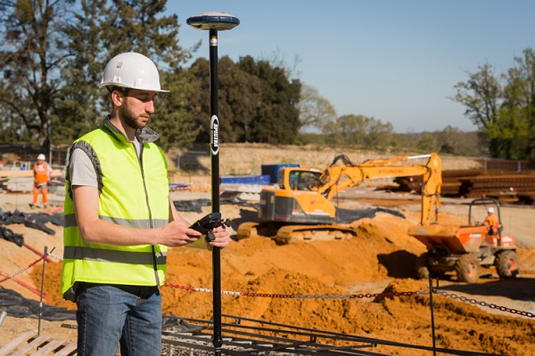
An altitude measurement with GPS is possible. GPS stands for Global Positioning System. With this system the position can be determined all over the world. And in addition to x and y coordinates, this includes a z value, or altitude.
However, elevation measurement with GPS is more complex than just determining position in the horizontal plane. This has a number of factors. First, GPS receivers do not measure the NAP elevation. The elevation measured with GPS is an elevation relative to an ellipsoid. With software such as the surveying app Apglos Survey Wizard, however, it is possible to take elevation measurements with GPS in NAP.
To make everything clear on this topic, we will answer the following questions in this article:
- What is an altitude measurement with GPS?
- Why isn't GPS altitude measurement from a phone sufficient?
- How is altitude determined with GPS?
- What about communication between the GPS receiver and Apglos Survey Wizard?
- Why is Apglos Survey Wizard important for height measurements with GPS in NAP?
Height measurement with GPS: the solution
You may not have the opportunity to read this entire article. Therefore, here is another opportunity to learn more about altitude measurement with GPS.
You can try a GPS measurement system through this website. To do so, look directly at this page.
You can request a demonstration of one of our GPS surveying systems on the same page. At this demonstration you can also ask specific questions about height measurement with GPS and of course about other topics related to GPS surveying.
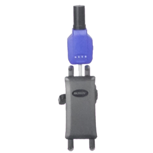
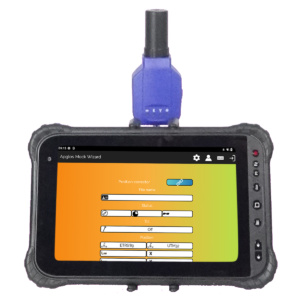
If you don't have time for a demonstration or want to try the software of our GPS measurement systems quickly in between, that is possible. Apglos Survey Wizard is the easiest software to perform GPS measurements with. You can download it for free from the Google Play Store.
The surveying app Apglos Survey Wizard has full functionality with your Android device's GPS. So you can fully test this app and it is free.
Of course, the accuracy of our GPS receivers is better than that of standard Android devices. So if you would like to do a test with an accurate system, check out this page.
What is an altitude measurement with GPS?
A height measurement with GPS is the measurement of heights in a terrain. This can be an open field. But it can also be a residential area.
Heights are always important for new and existing projects. New projects must also match the existing situation in terms of heights. And the height of the existing situation is regularly monitored. In addition, height measurements with GPS are important so that one can make designs, where the water flows down. So height measurements are in high demand.
There are several ways to take elevation measurements. One of the most common is height measurement with GPS. This is because this method allows you to take height measurements quickly but also in a targeted manner. Many measurement methods are not as fast as working with GPS. And other measurement methods do not allow you to measure heights from a specific point. So an altitude measurement with GPS is the ideal method in many cases.
Why isn't GPS altitude measurement from a phone sufficient?
Most phones also include a GPS. Theoretically, one could perform an altitude measurement with a phone. However, there are a number of disadvantages.
The first disadvantage is that the height of the antenna is not known exactly. GPS measurements involve determining the position of the center of the antenna that receives the satellite signals. Phones and tablets are getting nicer, but phone makers do not specify exactly where the antenna is in the phone.
That in itself does not matter much if one wants to take an altitude measurement with GPS, where the deviation of the measurement may be larger the dimensions of the phone. However, there are other disadvantages.
The second disadvantage is that the phone is held by hand. Therefore, the height of the phone above ground level is never always the same. As a result, deviations in height occur. However, we can solve this by mounting the phone on a pole.
However then we are not there yet with the disadvantages. The third disadvantage is the size of the antenna, which picks up the satellite signals. The larger the antenna, the more accurate the position and thus the altitude can be determined. However, phone makers are focusing more on making their devices smaller and more manageable. As a result, the GPS antenna in the phone is also small. Because of this, the deviations of GPS measurements with a phone are fairly large. In any case, too large to make an altitude measurement with GPS accurate.
But the last drawback gives the biggest discrepancy. By default, the phone does not give the correct elevation. Because they are GPS results it is of course not a NAP height. How the NAP elevation is determined in an altitude measurement with GPS we describe later in this article. By default, a phone displays the orthometric altitude.
And to better understand that, more needs to be explained about how GPS altitude is determined and the communication between a GPS receiver and Apglos Survey Wizard.
How is altitude determined with GPS?
The height that one can use in height measurements with GPS to eventually arrive at a NAP height is the height from ground level to the ellipsoid. An ellipsoid is nothing more than an oval that is a model of the earth, taking into account that the earth is flattened at the north and south poles.
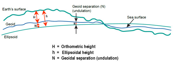
The desired altitude from the altitude measurement with GPS is indicated in the figure by h. However, the phone's GPS by default gives the height H again. To the orthometric height (H) you still have to add the geoidic separation (N). The phone does not do this automatically.
What about communication between the GPS receiver and Apglos Survey Wizard?
But it can be done automatically. This is because it has to do with the communication of the GPS receiver. The GPS receiver communicates using NMEA rules. One of those rules is the GGA rule. A GGA rule looks something like this:
$GPGGA,172814.0,3723.46587704,N,12202.26957864,W,2,6,1.2,18.893,M,-25.669,M,2.0,0031*4F
The various entries are separated by a comma. The following is the meaning of the fields, with the first field equal to $GPGGA and counting further to the right.
1 $GPGGA Message type.
2 172814.0 coordinated world time of position
3 3723.46587704 Position Latitude
4 N Direction of latitude
5 12202.26957864 Longitude
6 W Direction of longitude
7 2 GPS quality indicator
8 6 Number of satellites used
9 1.2 horizontal dilution of precision
10 18,893 Orthometric height
11 M Unit of orthometric height
12 -25,669 Geoid separation
13 M Unit of geoidic
14 2.0 Age of differential GPS data
15 0031 ID of the reference station
16 *4F The checksum data
Thus, the GGA line specifies both the orthometric elevation and the geoidic separation. Unlike latitude and longitude, two fields are needed to determine GPS altitude, which in turn can be used for an altitude measurement with GPS.
Why is Apglos Survey Wizard important for an elevation measurement with GPS in NAP?
And by default, a phone or a tablet does nothing with these two values. That's why you need surveying software that processes this data. And the best surveying software out there for that purpose is Apglos Survey Wizard.
Apglos extracts the correct data from the GGA rule and immediately converts it to the correct value. However, that's not all. Because the ellipsoidal height is not equal to the NAP height.
And when a height measurement is done with GPS, the result should be with NAP heights in the Netherlands. This has to do with the fact that people once thought that water would always flow downhill.
And so it would be, if gravity were the same everywhere in the world. However, it has been shown that this is not the case. This means that if the ellipsoidal altitude were used for altitude measurements with GPS it could be that water could flow from low to high.
And that's exactly what we don't want and thus why we take altitude measurements with GPS.
Therefore, Apglos Survey Wizard must perform an additional step. In this step, Apglos Survey Wizard calculates from a database what the anomalies are due to variations in gravity.
By performing this step, the results are such that water will flow from high values to low values. These are then the actual NAP heights.
Final conclusion on altitude measurement with GPS
This was a whole article on altitude measurement with GPS. There is a lot to report on this topic of GPS surveying. So we hope that you have picked up at least a few things from it and can take advantage of them.
However, everything written in this article is theory. If you want to put this theory into practice you can.
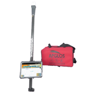
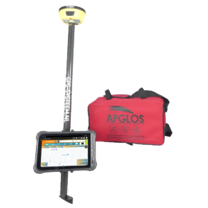
Indeed, you can use this website to purchase a GPS measurement system try or buy one. When you do then you can immediately put into practice what you have learned by reading this article on height measurement with GPS. And you can see if working with our GPS measuring equipment is something for you.
Of course, when you try or buy one of our GPS measurement systems, you will receive a short and clear explanation so that you can get started with it right away.
If you would like a demonstration first, you can also request one through the pages mentioned above. With a demonstration or a short explanation you can also ask specific questions about altitude measurement with GPS.
 Want to schedule a demo? You can do that through whats!