Staking out a building is a common task in new residential or commercial construction. Often the plotting of a building is done in several phases, because the construction of the building is also done in several phases.
To stake out a building is to mark in the field the corner points of the building. This is often done with wooden stakes. But in addition to the building corner points, one can also stake out the piles, or the building pit. A building can be plotted with a total station or with GPS. The easiest way is with GPS, especially if one uses Apglos Survey Wizard.
To make everything clear on this topic, we will answer the following questions in this article:
-What is eviction?
-What methods are there to stake out a building?
-Why is using GPS to plot the building the best way?
-What parts of a building can be plotted with GPS?
-How can GPS plot a building?
Building eviction: the solution
You may not have the opportunity to read this entire article. That is why there is another opportunity to learn more about building eviction.
You can try a GPS measurement system through this website. To do so, look directly at this page.
You can also request a demonstration of one of our GPS surveying systems. At this demonstration you can also ask specific questions about building surveying and, of course, about other topics related to GPS surveying.
If you don't have time for a demonstration or want to try the software of our GPS measurement systems quickly in between, that is possible. Apglos Survey Wizard is the easiest software to perform GPS measurements with. You can download it for free from the Google Play Store.
The surveying app Apglos Survey Wizard has full functionality with your Android device's GPS. So you can fully test this app and it is free.
Of course, the accuracy of our GPS receivers is better than that of standard Android devices. So if you would like to do a test with an accurate system, check out this page.
What is expansion?
The word expand has two meanings. It means that an object becomes larger. It is caused by the object getting warmer.
But within the discipline of surveying, surveying means something different. By plotting, then, one means marking out in the field points and lines of a given design.
For example, when a building is designed, it is of course convenient that the building is eventually built in the right place.
Therefore, the building is always plotted. From the drawing, coordinates are determined. In the Netherlands, the RD system is used for this purpose.
These coordinates are loaded into the surveying equipment. The surveying equipment tells the surveyor when it is at the exact location of the chosen point. The surveyor will then mark the point.
This is often done with wooden pickets.
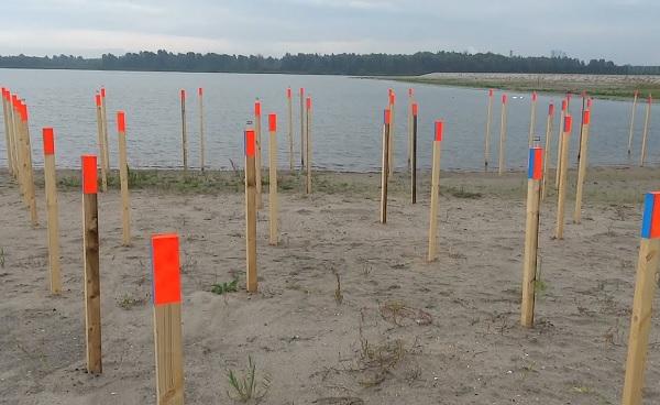
Using these wooden pickets, the builder can then see where the building should be located.
Plotting is basically the translation of the drawing into points in the field.
What are the methods for plotting a building?
There are different methods for plotting a building. Therefore, a surveyor has many different pieces of equipment. These include a level instrument, a GPS measuring system or a total station.
But not all measuring equipment can be used to plot a building. The most commonly used methods are with total station and with GPS.
Plotting with a total station
When working with a total station, some reference points are first determined. These are the fixed points a total station needs to determine the coordinates of the prism.
Reference points are often determined with a GPS system. Because of this, the accuracy of a total station is no better than that of a GPS measurement system.
In the total station a lot of computation happens. By using reference points, the total station knows what coordinate it is at and in what direction it is facing.
Furthermore, the total station can determine the distance and angle to the prism. In this way, the total station can determine all coordinates within the points of the reference point network.
If points outside the reference point network are determined then the deviation will be greater than desired. Thus, this is absolutely inadvisable.
So within the reference point network, it is quite possible to determine the exact coordinates of the prism. And so when the prism is at the exact position of the building point to be plotted, the surveyor can mark this point with a picket.
Plotting with GPS
Plotting with GPS is another method of plotting a building. The desired coordinates can also be loaded into this measuring device from drawing.
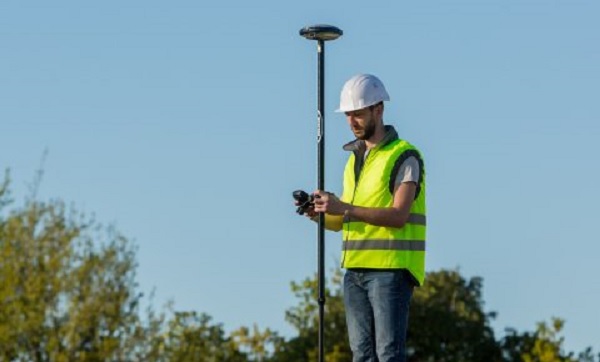
However, the GPS receiver, the sphere on top, continuously calculates where the GPS measuring stick is located. Therefore, with a GPS measuring system, one can find the coordinates anywhere in the world. No reference network needs to be determined here.
When the GPS receiver indicates the desired position of the building to be set out, the surveyor can mark this point with a picket.
Why is using GPS to plot the building the best way?
So there are actually two methods for plotting a building. As you have read above, there are some differences between the two methods.
The best way to stake out a building is with GPS. In fact, this is the easiest way, especially if one uses the surveying software Apglos Survey Wizard to stake out the building.
Apglos Survey Wizard is very easy to use and it is very intuitive software. You can download this software for free from the Google Play Store.
But anyway, GPS is the most obvious and best method for plotting a building.
Setting up a GPS measurement system compared to a total station is much faster. Moreover, in a GPS measurement system, one does not need to create a reference point network first, as one must with a total station.
The only thing to watch out for when plotting a building with a GPS measurement system is that the GPS receiver receives sufficient satellite signals. But since the construction of new structures often has in open areas, the GPS receiver usually receives sufficient satellite signals.
Another disadvantage of a total station is that sight lines must always be considered. The total station must have a view of all reference points and must have a view of the area where the building is to be plotted.
This can be tricky when part of the new building is already built or when equipment is moving around the site.
In short, the first choice for plotting a building is with GPS.
What parts of a building can be plotted with GPS?
With GPS, anything can be plotted. Many parts are also plotted with GPS when constructing a building.
Of course, vertices of a building can be plotted with GPS. But for the construction of structure, there are other phases.
For example, people often dig the building pit before building a home. This building pit must also be staked out. By staking out the building pit, the excavator operator knows where to dig.
Of course, one also sets out the piles. By plotting the piles, the pile driver knows where to drive the piles.
The same, of course, applies to the installation of the storage sheds.
It should be clear that setting out in the construction of structures is a regular occurrence and is very important for a good end result of the construction.
How to use GPS to plot a building?
Plotting a building with GPS is easy. And it is much easier than with a total station. The question, then, is how to stake out a building.
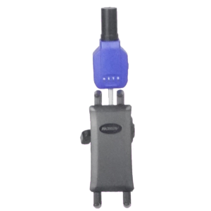
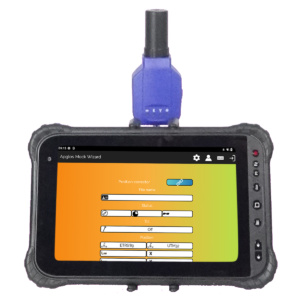
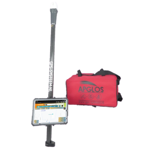
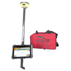
Of course, the GPS survey system must first be set up, which consists of a GPS receiver, a tablet, a tablet holder, a survey stick and, of course, Apglos Survey Wizard.
Then a connection must be made between the surveying software and the GPS receiver.
Below you can see how easy that is with Apglos Survey Wizard.
Then you need to make sure that the coordinates of the desired points of the building are in the software. This can be done by opening a DXF file or a point list in CSV or TXT.
When the points are loaded you can go to the stakeout screen. On the map you can select the point of the building to stake out.
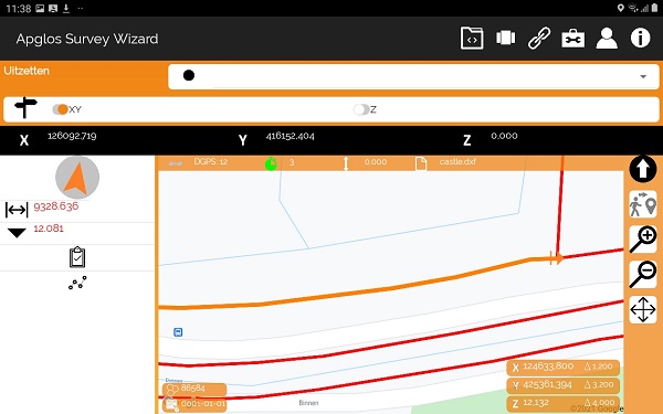
And then on the left side, you will see a number of things. From top to bottom, these are an arrow, indicating the direction from your current location to the desired point.
Below that is the horizontal distance between your current location and the point desired from the building.
And below that is the height difference between the current location and the desired point.
When the horizontal distance is less than 1 cm then you will hear a sound, letting you know you are at the location of the desired point.
So staking out a building is very easy and with one of our GPS measurement systems you can do it all by yourself.
Final conclusion on plotting a building
This was a whole article about plotting a building. There is a lot to report on this topic of GPS surveying. So we hope that you have picked up at least a few things from it and can take advantage of them.
However, everything written in this article is theory. If you want to put this theory into practice you can.
Indeed, you can use this website to purchase a GPS measurement system try or buy. When you do then you can immediately put into practice what you have learned by reading this article on building plotting. And you can see if working with our GPS surveying equipment is for you.
Of course, when you try or buy one of our GPS measurement systems, you will receive a short and clear explanation so that you can get started with it right away.
If you would like a demonstration first, you can book one here. During a demonstration or a brief explanation you can also ask specific questions about a building plot.
 Want to schedule a demo? You can do that through whats!